Page 3 of 5
Posted: Thu Jun 30, 2005 5:25 pm
by dzjepp
This program should be used in geography classes, imagine how much more interesting things would be =D
Posted: Thu Jun 30, 2005 5:28 pm
by dzjepp
Or have someone make a risk plugin or a crude strategy game of sorts, with 2d soldiers and vehicles... domination on a global scale MUAHAHAHHAHA!
Posted: Thu Jun 30, 2005 7:30 pm
by bork[e]
Thanks for your interest in Google Earth, but we're sorry we can't offer you a download right now.
What a load of crap.

Posted: Thu Jun 30, 2005 7:34 pm
by Guest
Hello my friends.
I is a real fantastic tool just as World Wind.
Man, it must be hallucinating being on the top of it.
Pete
Posted: Thu Jun 30, 2005 7:45 pm
by Guest
Damn wish I could download that here. I'd show you the clubs I go to around town :icon19:
Posted: Thu Jun 30, 2005 7:48 pm
by Guest
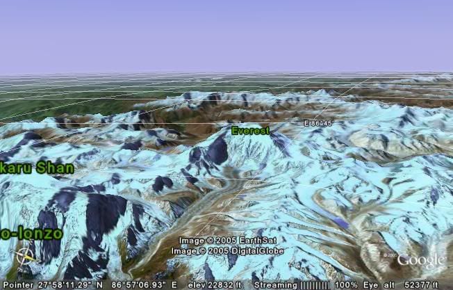
Here is a pic I took from the top.

Well of course not me but I wished.
Pete
Posted: Thu Jun 30, 2005 8:15 pm
by Synergy
check out cam1 in Times Square...live streaming video and audio.
40°45'31.67"N, 73°59'05.89"W
or here's the link right to the cam...
http://www.earthcam.com/usa/newyork/tim ... .php?cam=1
Posted: Thu Jun 30, 2005 8:43 pm
by rep
bork[e] wrote:Thanks for your interest in Google Earth, but we're sorry we can't offer you a download right now.
What a load of crap.
http://www.majorgeeks.com/download4659.html Hopefully it works for you.
Posted: Thu Jun 30, 2005 9:30 pm
by GONNAFISTYA
This thing is fucking cool.
I've been using Google's regular picture maps pages...along with using Celestia from time to time...but this thing is the best of both worlds when it comes to checking out Earth.
Posted: Thu Jun 30, 2005 9:32 pm
by rep
GHOST CARS in NYC!!!: 40°45'36.91"N, 73°59'4.04"W
WTF! UFO IN NYC!!!: 40°45'10.02"N, 73°58'56.93"W
Posted: Thu Jun 30, 2005 9:34 pm
by plained
hey hey i like that
and yea this gooearth thing is neat ey no wonder the 300 .
they really done shrunk up the world there
Posted: Thu Jun 30, 2005 9:51 pm
by o'dium
disney land;
48°52'13.46"N, 2°46'46.87"E
Posted: Thu Jun 30, 2005 10:19 pm
by rep
Cloaked Stealth Planes leaving chemtrails (Zoom out to 25Miles altitude. Clear 40 mile long chemtrails, no planes.): 46°27'24.21"N, 70°35'37.81"W
Posted: Thu Jun 30, 2005 10:22 pm
by saturn
I got bored real quickly, gonna give it another try
Posted: Thu Jun 30, 2005 10:24 pm
by rep
UFO landed in Canada 600,000 years ago? (Someone explain this land formation with a 20 mile radius): 51°22'55.31"N, 68°42'37.35"W
Here's a picture. Check out those clouds... !

Posted: Thu Jun 30, 2005 10:33 pm
by o'dium
That is VERY fucking odd... And look just up above it on the coast line, an ever bigger perfectly formed curve to the coast line that looks waaaaaaaaaay to perfect to be done by anything natural...
Posted: Thu Jun 30, 2005 10:36 pm
by o'dium
If you ask me, with all these perfect circles all over that place, i think its a galactic war raged millions of years ago DEATH RAYS I TELL YOU!
Posted: Thu Jun 30, 2005 10:41 pm
by rep
Posted: Thu Jun 30, 2005 11:46 pm
by Kammesennin
So the city would be Incirlik?[/quote]
Well, the Airforce Base is called Incirlik, however if the city is any different, I have no clue unfortunately.
Posted: Fri Jul 01, 2005 1:33 am
by Kammesennin
40°40'42.26" N, 73°25'01.18" W
What the hell? In Amittyville at that!
Posted: Fri Jul 01, 2005 2:51 am
by Guest
rep wrote:UFO landed in Canada 600,000 years ago? (Someone explain this land formation with a 20 mile radius): 51°22'55.31"N, 68°42'37.35"W
Here's a picture. Check out those clouds... !
Good evening my friends.
I recognised this place right away because I even flown over it a few times when I was working in the great north in 1979.
It is now named reservoir Manicouagan and it supposed to have
been formed by a meteorite.
Pete
Posted: Fri Jul 01, 2005 3:55 am
by Guest
riddla wrote:did it also have goatse clouds back then?
Can't recall.
Unbelievable to see all the water below though.
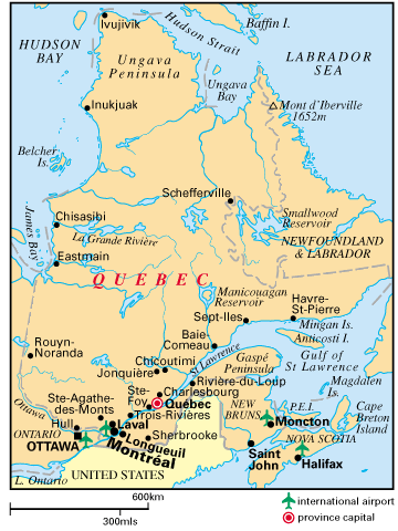
Quebec is the richest place for natural drinking water.
Take a look at the top of the map Ivujivik This is the closest place from where I was working a village of around 600 Inuits (Esquimos) If you find another map the right place is called Deception Bay next to Sugluck. That was an asbestos mine wich has closed in 1980 because of the cancer/asbestos case.
Pete
Posted: Fri Jul 01, 2005 3:59 am
by rep
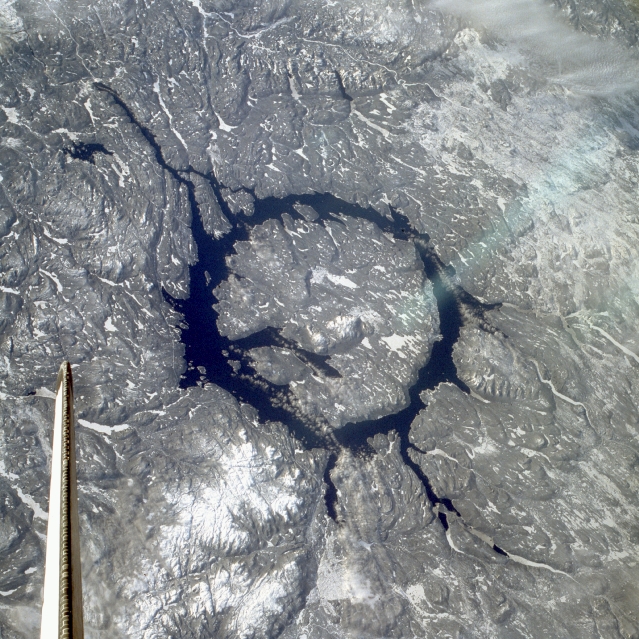
Here's a photo from space. (Notice Orbiter Columbia's tail.)
Posted: Fri Jul 01, 2005 4:12 am
by bork[e]
123
Posted: Fri Jul 01, 2005 4:13 am
by bork[e]
Think I did something wrong. :lol: